(Library of Congress Copyright Office – VA 1-256-506)

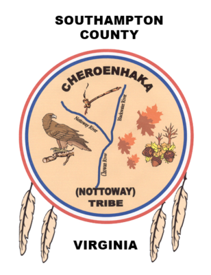
The Cheroenhaka (Nottoway) Tribal Shield was designed by the Tribal Council to reflect the history of the “Historic” Cheroenhaka (Nottoway) Indian Tribe. Beginning at our first appearance in the ethno-historic records in 1608, when members of the Jamestown Colony traveled to Nottoway County, Virginia to inquire as to the fate of the “lost” Roanoke Colony; to include, the current reorganization of the historic tribe. The Shield depicts 400 + years of Cheroenhaka (Nottoway) Indian survival, through three peace treaties, accompanied by wars, the white man’s disease, such as small pox, and “forced dispersal” from our native lands, as a result of colonial encroachment, economic suffrage and violations of our treaty by the Colonial Council and the Commonwealth of Virginia.
The Circle
Represents the circle of life. The outer circle reflects our walk in this sacred circle of life in that we must have a positive impact on the walk of another. The inner circle is our children and our children’s children.
Red, White and Blue Rings: Represents our Tribal Colors in that our “Regalia Dress” as reported by William Byrd in April 7th & 8th , 1728, while visiting one of our Cheroenhaka (Nottoway) Indian Towns in Southampton County – “the young men danced to the beat of a gourd drum, stretched tight with a skin – the women wore Blue and Red Match Coats with their hair braided with Blue and White beads.” The colors also represent our loyalty and patriotism; we fought in the French and Indian War at Fort Duquesne, Penn., in 1754 and in the Revolutionary War, where one of our werrowance / Teerheer / Chief was killed. The white ring also represents the purity of our worship and our devout belief in the One Creator – “Quaker-Hun-te,” our Lord and Savior Jesus the Christ.
Four Feathers: Represents the four directions – east, west, north and south; to include, the “forced dispersal” of our people from our ancestral lands. Colonial encroachment and economic suffrage “forced” many of our people to disperse to the four winds – east, west, north and south; however, the majority of our tribal members remained in their native Southampton County, Virginia – we are here today.
Eagle Perched: A Bird of Prey, looking back, never forgetting who we are, remembering our native roots. Representing the spirit, steadfastness and determination of the Tribe to reunite from the four directions the Cheroenhaka (Nottoway) Indian Nation. To “make right” the incorrect history by teaching our traditions, culture and the true history of our people to the masses.
Cheroenhaka (Che-ro-en-ha-ka): Is the name that we have always called ourselves. It means “People At The Fork of The Stream.”
Peace Pipe: Represents the three Treaties that we signed with the Colonial Government – the Treaty of 1646; the Treaty of 1677 (“Two Pom Wompon” – Middle Plantation-Williamsburg), and the separate Treaty with only the Cheroenhaka (Nottoway) Indian Tribe, February, 1713-14, bearing the signature(s) of Colonial Governor Alexander Spotswood and mark of our Teerheer, “Ouracoorass Teerheer,” at Williamsburg, Virginia – a treaty, from our tribal perspective, has never been negated and is still in force.
Three Rivers (Nottoway; Blackwater & Chowan): Represents the mark of our Teerheer (three rivers running parallel) as affixed to the Treaty of 1677. It also represents the location of our “Reservations Lands,” as granted by the House of Burgess in 1705-06 (some 41,000 acres –The Circle and Square Tracts). We lodged and hunted as far as the Albemarle Sound along the Chowan River. Here we called ourselves, “People At The Fork of The Stream.” – the fork where the Nottoway and the Blackwater Rivers join.
Leaves, Oak Trees & Acorns: Represents the Fall Season of the year when our “young” Tribal Men rejoiced, traveled, hunted, trapped, fished with “Rock Weirs,” foraged for foods, built “Long Houses,” took wives, and made war on enemy tribes.
Large Tan, Reddish Brown Circle: Represents our lively-hood, the land we farmed, the corn, beans, squash we grew; the hogs we raised, the many hides we trapped, tanned, traded, and made into clothes to protect ourselves from the climate. The color also applies to our complexion – according to the diaries of William Byrd, while visiting the Reservation of the Cheroenhaka (Nottoway) Indians, 1729, in what is now present day Courtland, Virginia ( Southampton County), wrote: “the women came out dressed in their Red and Blue Match Coats that fitted loosely about their bodies that their mahogany (Reddish Brown) skin shone through – though they were sad but colored, they would make exceptional wives for the English Planters and their dark skin would breed out in two generations.”
(Nottoway): Represents the “derogatory name” by which history remembers us. A name given to us by our enemy, the Algonquian Speakers, which means “Snakes” or “Adders.” In 1650 Edward Bland traveling with some Algonquian Speakers came upon a young werrowance (Cheroenhaka (Nottoway) Leader) and they, the Algonquians, referred to him as “Nadawa” – thus the name Nottoway enters the annuals of Colonial History; however, we call ourselves Cheroenhaka – “people at the fork of the stream.”
Southampton County, Virginia: Represents our ”ancestral” native lands, the Circle and Square Track; the location of two of our “Quiocosine,” (Qui-o-co-si-ne), burial grounds/cemeteries of our ancestors, some of which still remain and others, who’s spirits never sleep, for some 132 Cheroenhaka (Nottoway) Indian Graves were violated by excavation, removed, card cataloged, and remains left on a shelf at the National Museum of Natural History, in Washington, DC – Hand Site Excavation 1963 (44SN22). Currently this site falls under the May 24, 1996 Executive Order as a “Sacred Indian Site.” Southampton County, Virginia is the home of the “Historic” Reorganized Cheroenhaka (Nottoway) Indian Tribe, whose Chief “Teerheer” is the Honorable Walter D. “Red Hawk” Brown, III, Lieutenant Colonel, US Army (Retired).

